

International Eurasian Academy of Sciences, IEAS

Academician
Showcase the profiles of Academicians, gathering industry elites and experts to present their professional backgrounds and academic achievements, building an elite platform for member display and communication.
Home / Academician / Academician
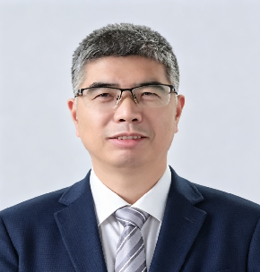
Manchun LI
Academician
Manchun LI
Profile:
Elected Academician of the International Eurasian Academy of Sciences in 2020, Professor Manchun Li is a distinguished Chinese geomatics scientist and a leading authority on geographic information technology, remote sensing, and territorial spatial planning. Born in June 1964 in Changzhou, Jiangsu Province, he earned his B.S. in Cartography from the Department of Geography, Nanjing University, in 1987, his M.S. in Cartography and Remote Sensing from the same university in 1990, and his Ph.D. in Human Geography from Nanjing University in 1997. He has spent his entire academic career at Nanjing University, progressing from teaching assistant to lecturer, associate professor, and ultimately Professor of Cartography and GIS in 2000. He has held numerous leadership positions including Director of the Remote Sensing Application Research Laboratory (1993–1995), Director of the Cartography and GIS Teaching and Research Section (1995–1999), Deputy Director of the Department of Urban and Resources Sciences (1999–2001, 2003–2006), Deputy Director of the Institute of International Earth System Science (2002), Director of the GIS and Remote Sensing Research Institute (2003), Deputy Dean of the School of Geography and Ocean Science (2006–2008), Party Secretary of the School of Geography and Ocean Science (2008–2011), and Director of the Science and Technology Division of Nanjing University (2010–2014). Since January 2016 he has served as Director of the National Virtual Simulation Experimental Teaching Center for Earth System Science.

His research programme is dedicated to geographic information science, remote sensing, and territorial spatial planning, with particular emphasis on the development of GIS technologies for urban and regional analysis, land-use change monitoring, and the digitalisation of territorial spatial governance. Through sustained leadership of national major research programmes and the development of virtual simulation experimental teaching platforms, he has produced transformative contributions to the education and application of geospatial science in China. Author of numerous peer-reviewed publications and monographs, he has been instrumental in advancing the integration of GIS, remote sensing, and spatial analysis into national territorial spatial planning and sustainable development strategies. Through sustained leadership of national teaching innovation programmes and international scientific collaboration, Professor Li has established a legacy that bridges fundamental geospatial science with the practical imperatives of smart territorial governance, ecological civilisation, and sustainable regional development across the Eurasian region.
